Bill's Ruby Crest Trail Hike
2009
by Bill Homan 2009
| Links | Lakes | Wildlife | Trail Info | Snow Report | Maps | |||
| Trail Heads | Ruby Crest Trail | Lakes Loop | Ruby Dome | Echo Lake | Island Lake | Verdi Lake |
|
Bill's Ruby Crest Trail Hike |
| During this hike I took a lot of digital photos in an attempt show the whole trail in different digital forms. If you would like to see some of these photos there are over 180 posted on flickr in my Ruby Crest Trail Set. |
| It had been 10 years since I hiked the Ruby Crest Trail. The first time I hiked this trail I went from Harrison Pass to Lamoille Canyon. This time I wanted to go in the other direction from Lamoille Canyon to Harrison Pass. On this hike I also carried an Amod AGL3080 GPS Data Logger and a digital camera. My goals for this hike was to gather as much data about the hike as possible for this site and see if I could hike it in the same amount of time as I did 10 years ago.
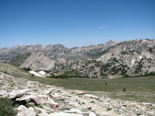
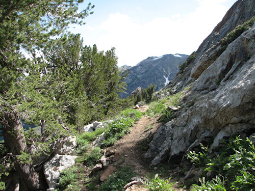
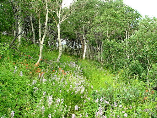
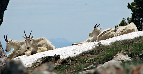
My pack weighted 29 pounds when I started on the trailhead. That weight is with water and food. My wife dropped me off at the trailhead in Lamoille Canyon and I started hiking at 06:20 Friday mourning 17 July 2009. There were a few cars at the turn around at the end of the road. There were also a few people at the in the parking lot. The first part of this hike from the trailhead at Lamoille Canyon to North Furlong is a gorgeous hike. The trail passes along Dollar, Lamoille, Liberty and Favre Lake. You can also see Castle and North Furlong lakes from the trail. The trail is good on this section and easy to follow. By 07:08 I was at Dollar Lakes and was at Lamoille Lake at 07:22. At 08:08 I was on top of Liberty Pass at 10,445 feet in Elevation. This is when I saw my first person on the trail. After a few minutes of hiking from Liberty Pass I came to an overlook above Liberty Lake. This is one of the best views that I know of in the Ruby Mountains, and I have been around a lot of the Rubies. I then dropped down into Liberty Lake and saw two more people fishing at the lake. I was at Liberty Lake at 08:30 and Favre Lake at 09:10. The hike from Favre to North Furlong is a nice hike through some tall limber pines with an occasional small meadow. I was on the saddle above North Furlong at 10:00. There is a stream that runs into North Furlong where I filled up on water for the dry trip across the top. Then I hiked up toward Wines peak. At the tree line between North Furlong and Wines Peak I found a shady spot and had lunch. I met two more hikers coming off of Wines Peak. These were the last hikers I saw till I reached Overland Lake. Lunch was over and I started to head up Wines Peak at 11:30 and was on Wines peak at 12:06. On the way up to Wines Peak I caught a hand full of mountain goats feeding in a grassy spot. I took in the view for awhile and then headed out from Wines Peak at 12:20. On the top of Wines peak the trail changes. Now you are on top of the Rubies. The trail flattens out and the vegetation is sparse and wind swept. As I hiked along the trail I noticed some mountain goats lying on a snow bank not far from the trail. I knelt down and grabbed my camera. There was a small hill between the goats and myself. This kept most of my body out of their line of site so I could get the camera without spooking them. I shot a few photos and the goats decided to move off. A minute or two after they moved off I went over to the side of the hill and looked over to see if I could find any of the goats. I could not believe what I saw. There where goats everywhere. I started taking photos in the hopes that I could count their numbers from the photos as I could not count this many moving goats on the spot. It ended up that from two photos I counted 40 mountain goats. After watching the goats for a short while and then I headed back down the trail. The trail stretched on along the top of the Rubies. I had great views down Mahogany Creek and Long Canyon. I really liked this section of the trail. It was like I was on top of the world with peaks stretched out for as far as I could see in front and behind me. To the sides I had spectacular views of Ruby Valley to my left and canyons stretching away from me to my right. At 15:08 I was at the end of this section of the hike and ready to drop down into Overland Creek. The scenery started to change again as I dropped off the top of the Rubies. The terrain was getting greener plus I started to find some blooming wild flowers along the trail. This added water and vegetation made it a great place for mule deer. While hiking this section I saw a few mule deer and even one coyote. The main thing on my mind though was getting water. I had just spent 3 hours in the sun hiking across the top plus I was not sure how far I had to go to find water. After almost an hour after I dropped off the top I found a stream running across the trail. I filled up and kept on going in the hopes to pull out of Overland Lake before I made camp. A t 17:45 I arrived at Overland Lake. The bugs were terrible but the fish were feeding off the top of the water like crazy. I met the sixth and last person here at Overland Lake. He was doing some fishing and doing very well. I headed up to the small lake above Overland to fill up on water. I knew from experience that filtering water up there would be easy. Once I had filled up on water I headed up the hill to pull out of Overland Lake. I was on top at 19:10 and made camp in a spot with a great view and a nice breeze that I was hoping would keep the bugs at bay. While I ate supper I watched the sun set and found a few mule deer feeding. Morning came and I was on the trail at 06:00. As I dropped off the saddle I ran into a lot of wild flowers along the hillside. This part of the trail was different than the rest. The trail cut thru stands of aspens and had wild flowers over a large portion of it. I crossed a few streams as the day went on. I went through the North, Middle, and South Forks of Smith Creek. It was 08:30 and I arrived at South Fork of Smith Creek. This was a good sized creek and a great place to fill up on water. I also found a couple of nice camping sites. After a short rest I headed back on the trail. I arrived at McCutcheon Creek at 11:00. At 12:00 I was at the end of the foot trail and ready to head down the 4 wheeler trail. From here on the trail was fairly dry but I knew the end was not to far away. The farther you head go on this part of the trail the better the road gets. Before long the 4 wheeler trail turned into a jeep trail and then into a decent dirt road. This part of the trail runs along Green Mountain and the makes a 90 degree turn and heads toward Harrison Pass. At 14:30 I was at Harrison Pass. This last part of the hike was hot and dry and I was glad to meet my wife at the car and have a nice cool Sprite. |
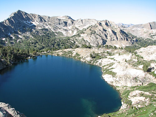 View from above Liberty Lake.
|