| Links | Lakes | Wildlife | Trail Info | Snow Report | Maps | |||
| Trail Heads | Ruby Crest Trail | Lakes Loop | Ruby Dome | Echo Lake | Island Lake | Verdi Lake |
 |
|
|
Lost Lake is a small lake located in Rattlesnake Canyon. This lake is at an elevation of 9,872 feet. The size and depth is not known although the lake is not very deep as you can see the bottom of the lake. This hike starts at the Overland Lake trailhead and takes me around 9 ½ to 10 hours to complete, this counts breaks. Most of this time is spent cutting across the back of a few canyons with steep slopes and numerous rock fields.
Starting at the Overland Lake trailhead can be hot so I suggest starting early before it gets to hot. Follow the trail into the mountains and after a few switchbacks and around 2600 feet elevation gain you will run into the Ruby Crest Trail. I would fill up on water here at the lake or at the small lake located just above Overland Lake. It usually takes me around 3 hours to get to Overland Lake and another 7 hours to get to Lost Lake. So make sure you have water to last until you get to Lost Lake. Go to the Trail Information page for more information on getting to Overland Lake.
From here I dropped a little of my elevation down to around 9600 - 9700 feet. I did this to get below the rocky cliffs between the back of Rattlesnake Canyon and Gennett Creek. Once I entered Gunnett Creek I kept my elevation the same until I was at the back of the canyon. Then I started to gain elevation and cut up toward the next saddle. Once there you can see a marsh below. Keep your elevation from here and cut across to the next saddle above Lost Lake. Once above the lake you can head straight down if you are in a hurry or stay to the left if you want an easier way to the lake. There is another option that you could take for this hike. On the way out I stayed high on or close to the ridgeline. This worked very well. The walking was a little easier because the slope was not always so steep and the rocks up high were larger and did not move around so much. One of the best things about this route is the scenery. The view was spectacular up there. There is a .kml file on the right of this page that shows the differance between the two routes.
September 2006 Trip Report: Lost Lake is located in Rattlesnake Canyon and I am told that this canyon is appropriatly named. Because of the snake issue and the fact that the mouth of Rattlesnake Canyon borders private property I decided to go to this lake through Overland Lake. Once you get to the trailhead head toward Overland Lake. This can be a hot hike in the afternoon but the mornings are a lot cooler plus there is a good chance you could see some deer or a coyote on the way to Overland Lake. The way to Overland Lake has a good trail that is easy to follow. Also the trail to Overland Lake has a lot of switchbacks. Once you get to Overland Lake follow the trail past the main lake to the upper lake. I would refuel on water at this point since this will be your last good chance for water. Then follow the trail up the hill until you reach the top. Once on top and with your back to Overland Lake say good by to the trail and make a right. Keep your elevation and start cutting across the hillsides. You will have to cut across the back of three canyons before you get to Lost Lake. North Fork Smith Creek is the first canyon you will have to edge across. Once you get to the back of this canyon you will be able to look into the back of Rattlesnake Canyon. Now you have only two more canyons to edge across. The back of the next canyon is small and will lead you to Gennette Creek. The back of Gennette Creek is good sized and took me at least an hour to get to the other side. Once you get to the other side of the ridge make sure you keep your elevation high so you can look over the edge and see just where you are in comparison to Rattlesnake Canyon. You will be able to see a march below you in Rattlesnake Canyon before you get to the pass above Lost Lake. Once at this pass you can head down the rocks right to the lake. Going to Lost Lake is not a short trip. The hike into this lake took me a little over nine hours. This time is from the truck to the lake. The last half of this hike you have to edge across the back of some canyons which will put a huge strain on your feet. There are only two other times that I have felt as tired as I was when I arrived at this lake. Once was after I spent around 12 hours and 20 miles on the trail the first day on my Ruby Crest Trail hike and another when Larry and I hiked into Lamoille Canyon from above Cold Lakes. OK and maybe when I would day hike Echo Lake. Just keep in mind this is a long day trip into this lake. Have fun. [maps needed 7.5 minute Franklin Lake NW]
|
An interactive map of the trail to Lost Lake via Overland Lake. Download .KML for Google Earth Here. This kml gives a 3D representation of the Ruby Mountains and this hike. When viewed in Google Earth there are more photos of the trail from me and other users. .kml File Here is a .kml file that can be opened with Google Earth. This file shows the differance between my route in and the high route out. To download this file in Google crome just click on it. If you are using IE 9 right click the file and choose "Save target as". Make sure you save the file as a .kml and not a .xml. To the Trail Head: The directions to this trailhead can be found at my Trimble Outdoors page Overland Trail Head.
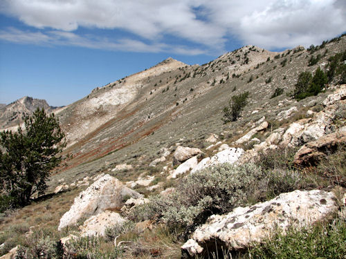
 The back of the North Fork of Smith Creek.
|