| Trail Info | Snow Report | Maps | Wildlife | Lakes | Search | |||
| |
||
Little Lakes Loop Hike |
||
|
The Little Lakes Loop Hike is a short version of the Original Lakes Loop hike. This hike is around half the length and is very convenient if you do not have the time to spend on the Original hike. This Little Lakes Loop hike is a 10 mile loop hike with Snow Lake located around the middle of the hike. This hike is around half on and half off trail. The off trail sections of this hike is a little more difficult than the longer original loop hike. You can see 8 of the Rubies 14 named lakes, plus beaver dams. This hike also takes you through prime habitat for mountain goats, Himalayan snowcock, pika and mule deer to name some of the wildlife that I have seen on this hike.
Named lakes that you can see on this hike are.(In Viewing Order) There are also beaver dams in Thomas Canyon. The time needed for this hike can vary greatly. I have done this hike with Larry as a long day hike taking 10 hours to complete. If you want to take your time and do some fishing and see the sights I would recommend at least one night and maybe two. You could spend the first night at Liberty Lake. This will add around an extra mile to the hike. Or you could hike to the half-way point of Snow Lake and spend the night there. The second night could be in the back of Thomas Canyon or Island Lake depending on your schedule. This should give you plenty of time to explore.
1st half of the hikeDollar Lakes, Lamoille Lake, Liberty Pass, Liberty Lake Overlook, Liberty Peak, Box Canyon and Snow Lake
This half of the hike is the easiest half with 3 of the 5 miles on trial. Start the Little Lakes Loop Hike from the end of the road in Lamoille canyon and take the trail past Dollar Lakes and on to Lamoille Lake. From here hike the trail to Liberty Pass. From the pass it is less than 10 minutes to the Liberty Lake Overlook. This is one of the best views in the Ruby Mountains. You can see Liberty and Castle lakes with 10,940 ft. Wines peak in the background. From the Liberty Lake Overlook you can follow the trail to the lake or head back to Liberty Pass to continue the hike to Liberty Peak, If you head to the lake this will add around an extra mile to the overall hike. There are great places to camp at the mouth of the lake. If you keep going to the Liberty Pass, hike back toward Liberty Pass and by the pass turn left (West) toward Liberty Peak. This is the end of the trail until Island Lake. From now on you really get to learn about the Ruby Mountains. I would suggest staying by the ridge line from Liberty Pass and walking it to the peak. This will keep you out of the loose terrain. The track on the track log shows a good way to the peak. Once on Liberty Peak at just over 11,000 ft. you can look out over the spine of the Rubies and see many named lakes. If you walk north east to the peak overlooking Lamoille Lake you can see 7 named lakes. They are Dollar, Lamoille, Liberty, Favre, Castle, Box and Snow lakes. This is a great view and definitely a highlight of this hike. Once you leave this peak you are experiencing just what the Rubies have to offer in regard to scenery and especially terrain. When you are done looking around head off the ridgeline and drop down into Box Canyon to the north west, away from Liberty Lake. Take it slow here as you are now heading down a 40% grade, welcome to the Rubies! This slope reminds me of the slope above Cold Lakes only Cold Lakes is steeper. I suggest dropping down to the top of the tree line at the back of Box Canyon (10,000 ft.). This will give you easier terrain to hike and still keep your elevation for Snow Lake. The track log shows a higher line that is good for looking into Lamoille Lake but it is not as easy to hike. Head along the back of the canyon staying around 10,000 foot in elevation and follow the back of the canyon to Snow Lake. Snow Lake is the halfway point for this hike. There are great places to camp here and awesome scenery. It is also a good place to stock up on water. The most difficult part of this hike is from the pass above Snow Lake to Island Lake. If you would rather turn back here it is possible to back track to the pass above Lamoille Lake and drop into Lamoille Lake and follow the trail back to the end of the road where you are parked. This will cut a few miles off the hike and make it a good bit shorter. There are two trails from Lamoille Lake to the Parking Lot. One is the trail you came in on and another is the stock trail. If you do take the stock trail make sure you follow proper trail etiquette when it comes to horses. Hikers yield to horses and go downhill from the trail when the horses pass. Remember horses can spook easily.
2nd half of the hikeThomas Canyon and Island Lake.
Once you come around the ridge head to the east side of Thomas Canyon. This is the side that is opposite from the beaver dam. You should be on top of a shelf that will lead you to the east side of the canyon. Follow the small cliffs around until you get to the spot that you can start your climb to the top. Now the fun begins. Work your way up the side of the ridge. The chute you want is directly above. Larry and I did this in 34 minutes and this was not killing your selves but we did keep a steady pace. This is the hardest part of the hike but it is not bad if you take your time. I like using this chute on the left (north) going up because it is easy to find going up and it does not have as much loose scree as the chute to the right (south). Also I do not think this chute is as steep as the other chute. I do not like heights and I was fine with the chute on the left, but if you think you may have problems you can always use the other chute. The chute on the right is closed in more, and for me helps with the issue of heights. Keep in mind though that the going will be slower because of the scree. Congratulations you are now on top above Island Lake and everything else is downhill clear to the parking lot. Plus you are in some of the best country for wildlife the Rubies. You are in the middle of mountain goat and snowcock country. Plus there are pika galore and beautiful views of Island Lake and the marshes above the lake. As a side note there is usually cell phone coverage on top of this pass. If you hiked up the chute on the left (north) then cut to the left (north) and you will be on a mountain goat trial that will lead you along the base of the cliff. This will take you to a spot that you can cut back and drop right out of the slope. If you came out of the chute to the right with the scree then head straight down and you can work your way out. The goal now is hiking to the mouth of Island Lake. You will be able to pick up the trail there and follow it to the parking lot. Tips for the Little Lakes loop Hike.
|
.kml File Here is the .kml that will be opened with Google Earth. If the track does not show check the box labeled "Track" in the left pane of Google Earth. 
To download this file in Google crome just click on it. If you are using IE 9 right click the file and choose "Save target as". Make sure you save the file as a .kml and not a .xml. Also to remove the snow in the Google Earth imagery Follow the Yellow line. 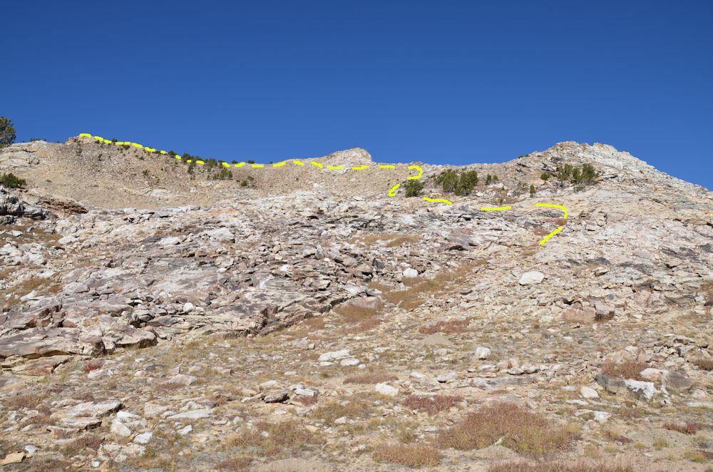
Photo taken from around wilderness boundry by Liberty Pass. 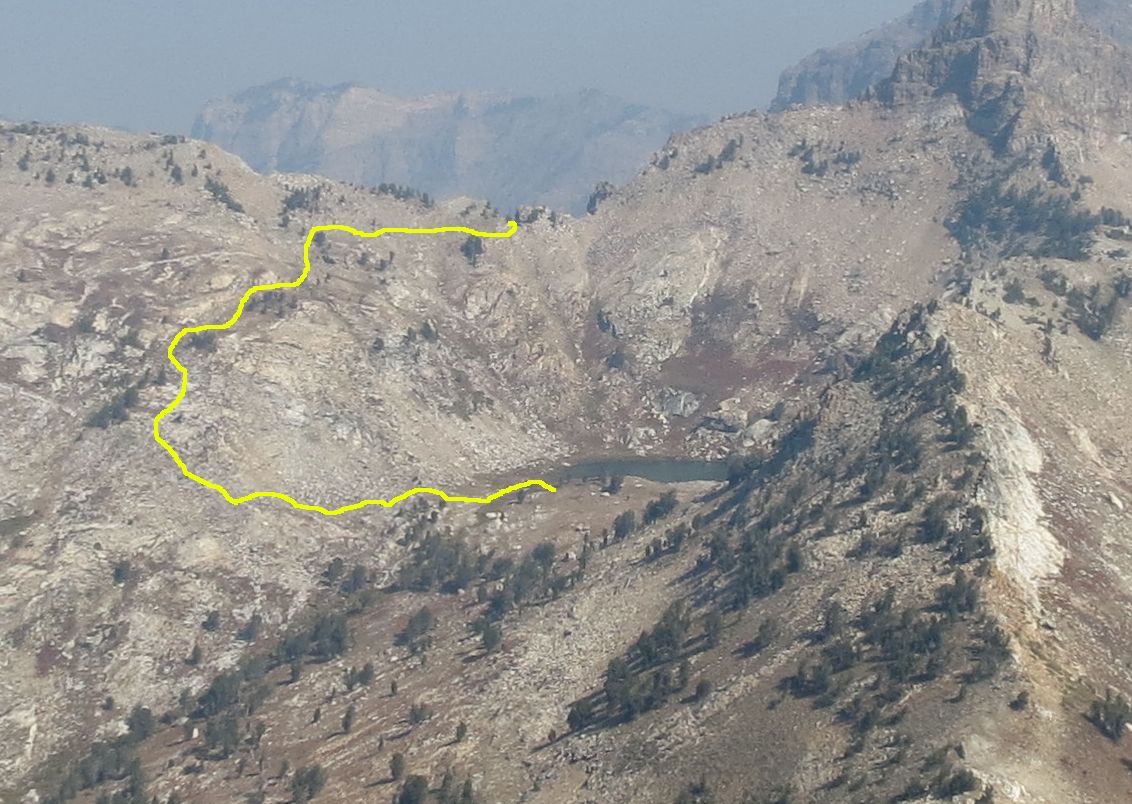
Follow the yellow line to the pass above Snow Lake. The smoke was very bad when this photo was taken. 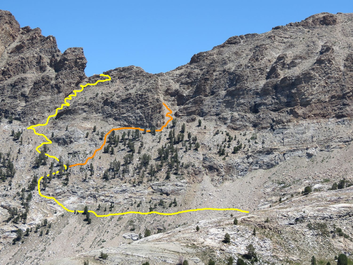
Photo taken from Thomas Cayon. The yellow line is the route Larry and I like. You can also use the orange line as an alternative route.
|

 From Snow Lake you want to hike to the past behind the lake. The best way to do this is hike the small ridge line to the west of the lake. This is a very easy hike to the past that Larry and I did in an easy 35 minutes. From the pass we descended into Thomas Canyon working our way through the loose rocks and dirt. You will want to keep to the right side of the canyon. There is a small grassy shelf around 10,000 ft. that you want to hike toward. This will lead you right over the ridge and set you up for the next section of the hike.
